
Cctv newsAccording to the website of the Central Meteorological Observatory, rain and snow occurred in Xinjiang, Inner Mongolia, Heilongjiang and other places during the day, and haze weather occurred in North China, Huanghuai and other places. It is estimated that in the next three days, there will be mild to moderate haze in Huanghuai and other places in North China, and there will be dusty weather in northwest China and other places on the 15th, paying attention to the impact on transportation and human health;
There is a risk of snowstorm disaster in the eastern part of Northeast China from 15th, paying attention to the impact on transportation, electric power communication, agriculture and animal husbandry, etc. There is a strong wind cooling in the northwest to the central and eastern regions, so pay attention to the impact on simple facilities, energy supply and maritime shipping.
First, the weather situation
1. There is rain and snow in Xinjiang, Inner Mongolia and Heilongjiang.
During the day, there were small to medium snow or sleet in northern Xinjiang, northeastern Inner Mongolia and southern Heilongjiang, and moderate rain or heavy rain in southern Yunnan. In addition, light to moderate haze weather occurred in parts of Guanzhong, Shaanxi, southwestern Shanxi, southern Hebei, and central and northern Henan. Sand-blowing or dusty weather occurs in southern Xinjiang basin, central Gansu, central Inner Mongolia and northwestern Shanxi.
2. Haze weather occurred in Huanghuai and other places in North China.
Second, the key weather forecast
1. There will be strong winds and cool weather in the central and eastern regions.
During the night of November 14th to 17th, due to the influence of cold air, the temperature in the central and eastern parts of northwest China, the eastern and southern parts of southwest China, and most parts of central and eastern China dropped by 4 ~ 6℃ successively, and the local temperature drop could reach more than 8℃.
Among them, from 20: 00 on November 14 to 20: 00 on November 15, there will be strong winds of 7-8 grades and gusts of 9 in the Taiwan Province Strait, bashi channel, northern and central South China Sea; There will be strong winds of 5-7 grades and gusts of 8-9 grades in parts of eastern Xinjiang and southern Xinjiang basin, Tibet, central and western Inner Mongolia, northern Gansu, Qinghai and Hainan Island. From 20: 00 on the 15th to 20: 00 on the 16th, there will be strong winds with 7-8 grades and gusts of 9-10 grades in Bohai Sea, Bohai Strait, most of the Yellow Sea, most of the East China Sea, Taiwan Province Strait, east of Taiwan Province, bashi channel, most of the South China Sea, Beibu Gulf and Qiongzhou Strait. Some areas in eastern Inner Mongolia, most of North China, most of Huanghuai and eastern Jianghuai will have strong winds of 5-7 and gusts of 8-9.The Central Meteorological Observatory continued to issue a gale blue warning at 18: 00 on November 14.(See Figure 1 and Figure 2.)。

Figure 1 National Gale Forecast Chart (20: 00 on November 14th-20: 00 on November 15th)

Figure 2 National gale forecast map (20: 00 on November 15th-20: 00 on November 16th)
2. There is rain and snow in Northeast China and other places.
From the night of November 14th to 17th, there were small to medium snow or sleet from west to east in parts of the central and eastern parts of northwest China, Inner Mongolia and Northeast China. Among them, from the night of 15th to 17th, there were heavy snowstorms in parts of central and eastern Heilongjiang and eastern Jilin.
Third, the specific forecast for the next three days
From 20: 00 on November 14th to 20: 00 on November 15th,There are small to medium snow or sleet in parts of central and northeastern northwest China, central and northeastern Inner Mongolia, western and northern North China, northern Sichuan Plateau and northeastern Tibet, and there is heavy snow locally. There are light rains and local moderate rains in parts of the southeastern part of the northwest, most of Henan, most of Hubei, most of Hunan, the eastern part of southwest China, and southern Yunnan. There are 4 ~ 6 winds in parts of the eastern part of northwest China, central and western Inner Mongolia, northern and western North China. There is sand blowing in the central and western Inner Mongolia (see Figure 3).

Figure 3 National Precipitation Forecast Chart (from 20: 00 on November 14th to 20: 00 on November 15th)
From 20: 00 on November 15th to 20: 00 on November 16th,There are small to medium snow or sleet in parts of central and eastern Inner Mongolia, most of Heilongjiang, central and eastern Jilin, eastern Liaoning and eastern Tibet. Some areas in southern Liaoning, eastern Shandong, Jiangsu, Anhui, Zhejiang, northern Fujian, Jiangxi, eastern Hubei, Hunan, southern Sichuan, Yunnan, Guizhou, north-central Guangxi, northern Guangdong, Hainan Island and Taiwan Province Island have small to moderate rain. There are 5 ~ 7 winds in parts of central and eastern Inner Mongolia, most of North China, Shandong Peninsula and eastern Jiangnan (see Figure 4).

Figure 4 National Precipitation Forecast Chart (from 20: 00 on November 15th to 20: 00 on November 16th)
From 20: 00 on November 16th to 20: 00 on November 17th,There are small to medium snow or sleet in parts of eastern Inner Mongolia, Heilongjiang, Jilin, northern Liaoning and eastern Tibet, among which there are heavy snowstorms in eastern Heilongjiang and northeastern Jilin. There are small to moderate rains in parts of southern Liaoning, southern Sichuan, most of Yunnan, Hainan Island and Taiwan Province Island. There are 5 ~ 7 winds in parts of central and eastern Inner Mongolia, most of Heilongjiang, western Jilin, most of Liaoning, Shandong Peninsula and eastern Jiangnan (see Figure 5).
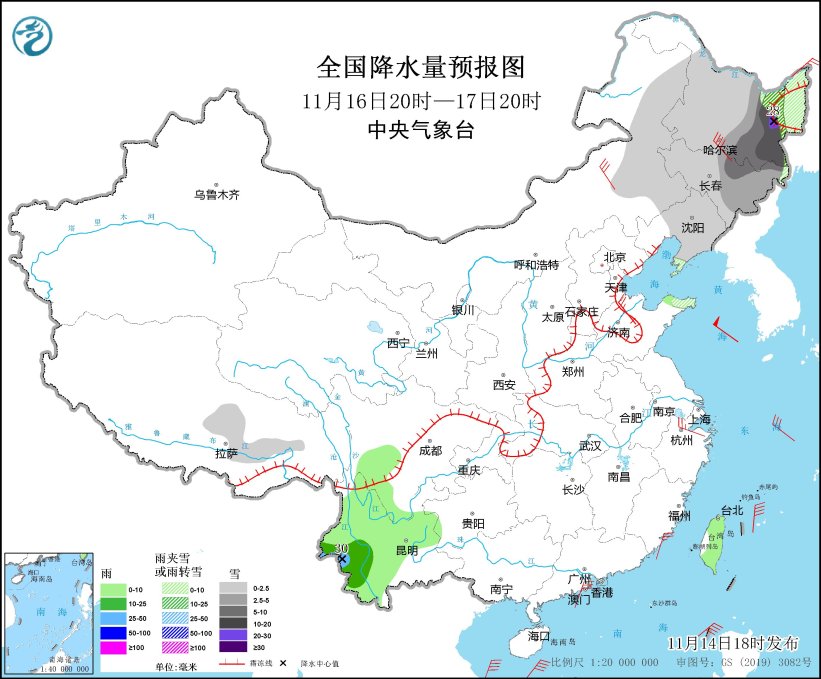
Figure 5 National Precipitation Forecast Chart (from 20: 00 on November 16th to 20: 00 on November 17th)